
www.instagram.com/p/B3PLERagsd9/
Indian wear/ Indian traditional wear
https://www.instagram.com/p/B3PLERagsd9/?igshid=ayy7ksm70ai3
www.instagram.com/p/B3PLERagsd9/
Indian wear/ Indian traditional wear
https://www.instagram.com/p/B3PLERagsd9/?igshid=ayy7ksm70ai3


LADAKH means the land of high passes. I want to share one of the most memorable trips of my life. During this trip, I learned a lot and I enjoyed a lot.
LADAKH was a dream destination for me. For so many years, I wanted to go there, but I wanted to visit Ladakh with my three children and of course, my hubby. Till now, my children were very young and of when you visit such places, the kids must be of a certain age, so that they can also enjoy and at the same time parents too can do so. That’s why it got delayed, but it was always on the list.
For LADAKH, we made the travel itinerary by ourselves. One of my friends, who had traveled earlier in that region, also helped and inspired. During the entire process of making the travel plan for LADAKH, I was very excited. I was very curious about the HIMALAYAS, I wanted to visit that region thoroughly, so when planning the itinerary, we made sure to plan stays of at least two to three nights at each destination. So after including all the places of our interest in the itinerary, a tour plan of 21 days was made.
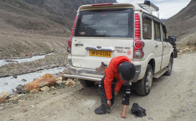
We decided to travel by our own SUV, the Ford Endeavor 4×4, with terrain assist features, a model most suitable for the rugged roads of Ladakh. In fact, we had decided that we should plan for LADAKH only if we can travel by road, that too a four-wheel drive SUV. So we bought this vehicle, only with the reason of taking it on this tour.
We knew that we wanted to explore this region in various ways. In the past, we only did luxury tours. But this was going to be a very thrilling, all terrain experience. So mentally I was prepared for a rugged tour and I prepared my children also that way. We all were ready to concur this. I gathered all the knowledge about this region – like how would the weather be, what would be the extreme conditions, what would be required, what medicines should be taken along, how much food and what type of food should be carried, everything. We bought suitable clothes, winter wear, thermals, scarfs, caps, woolen socks, all weather jackets, all-weather shoes, one big tent so all 5 of us can be accommodated, stools, kitchen vessels, stove, water tumbler, plastic plates, spoons, disposable glasses, paper napkin roles, newspapers for collecting waste, extra bed sheets (what if we didn’t get clean bed sheets so generally I keep bedsheets and rugs with me always, when I travel by road), a brush to clean the car from inside, small compact bucket for multiple uses, knife to cut fruits and vegetables, neck pillows for all of us (as we have to travel 21 days in a Car), a rope, 2-3 types of footwear for each of us, one for the room , other to wear during traveling and one pair of all-weather shoes for the outdoors. We also took lots of music for everyone.
Here is another list for other essential items we carried: Toiletries, cold cream, petroleum jelly, mosquito repellent for body and room also. So I packed up all these basic needs. We took dry fruits, God of Gujarati nasta (snacks) – Theplas, Pickles and Garlic chutney. So All the required preparations were done. Bingo! We were ready to roll!
We all were very excited and ready to go. The night before the D-day, we put all our luggage in our Car, we arranged the baggage such that – we all could sit comfortably and all required things would be easily handy.
Next day early morning we left on our great journey. Every four hours or so, we took break for food and for the call of nature. We reached Udaipur by evening, which is at a distance of around 760 km from Mumbai. After getting fresh, we relaxed, had some walk, chatted with each other regarding the first day’s experience. Everyone was comfortable and enjoying too, so all good. Next day early morning by seven, we left for Panipat. We were traveling in the month of May and during that period, the temperature was so high that it touched 50 degrees. Till the time we kept moving in the car there was no problem of heat, but whenever we were out of the vehicle, the situation was really bad. We traveled almost 750 km to reach Panipat from Udaipur. So by the night time, we reached Panipat. All our Hotels were booked by us when we planned our trip. So there was no issue of looking for places to stay.
Next day early morning, we left for Jammu after having our breakfast. We traveled 505 km from Panipat to Jammu. We were reaching all the destinations very smoothly without any hassles. So by late afternoon, we reached Jammu.

There we stayed at HARI NIWAS Palace Hotel. It’s the beautiful old palace of the Maharaja of Jammu, which is converted into a hotel. Nice comfortable luxurious hotel. We stayed there for a day and next day we left for Srinagar.
I was very excited because the journey to the HIMALAYAS was about to begin. Curvy mountain roads started, the weather was getting much cooler, the terrain was changing, people around were different. So we traveled around 300 km. and reached Srinagar by late afternoon.
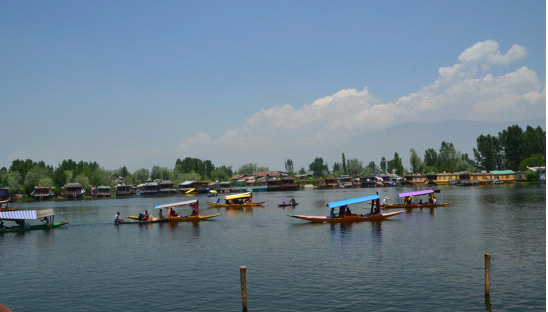
We had booked a House Boat at the Dal lake. We experienced houseboat stay, site seeing in Srinagar and stayed there for a day. Next day we left for Gulmarg.
Gulmarg is so beautiful, indeed Heaven on the Earth. Very first time, I realized that when I took a breath, oxygen went through all the way from my nose right up to my navel point. It was as if I was getting high on Mountain air! We stayed there for two days. During the Gulmarg stay, we took a ride on the Gondola – a beautiful cable car. The gondola is a cable car which takes tourists to the Kongdoori Mountain. There are two stages of this cable car. Stage one is from Gulmarg resort to Kongdoori Station, at 8530 feet, up through a bowl shaped Kongdoori valley.

The second stage of the ropeway takes skiers to a height of 12293 feet. At the height of 12293, every side of the site was covered by snow, white all around.
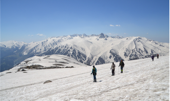
Many locals were offering skiing experience to visitors. It was so nice and beautiful, I had never seen so much snow in my life. Many trekking routes were available there.

After spending a few hours there, we came back to our hotel. By 4 pm, we went on a trail to the Gulmarg golf course, enjoyed all day, and returned to the hotel.
We then prepared for our further journey to the LADAKH region in Jammu & Kashmir. We knew that the LADAKH region is very rough, rugged and at a very high altitude. So I was worried about the high altitude sickness, discomfort in the body , sickness and headaches resulting due to thin air, and low oxygen levels etc. But we were carrying all required medicines, including Oxygen cylinders, and were aware of the circumstances.
Next day early morning after heavy breakfast, we left for Kargil. In Kashmir, everything was so serene and beautiful. As we left Gulmarg, everything around was so beautiful and air so pure. I can say, one can inhale 100% oxygen in every breath. there. You feel so fresh and energetic and alive.

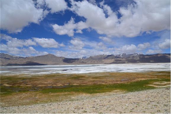
By noon, we reached Sonmarg, which is around 120km from Gulmarg. Also known as “Meadow of Gold” and is at around 10000 feet above sea level. Sindhu river passes parallel to the road, sometimes just next to the road. It looks so beautiful. It was still the early part of summer, so many glaciers were approaching the river and even the sides of the roads.
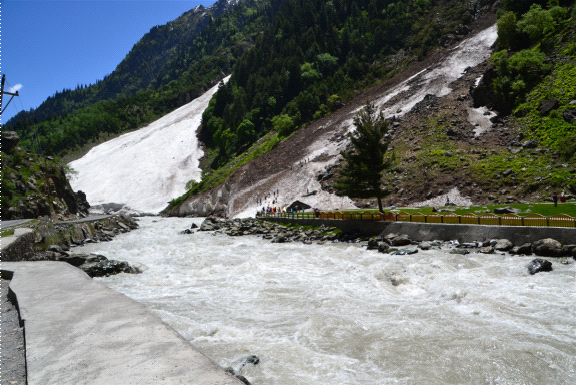
It is nice green during summers. The scenery was a mix of bare dry hills, glaciers, and very green landscapes. Before entering Sonmarg, at one location, on the Sindhu river bank, a Glacier was meeting the river. We stopped there for a while, enjoyed the beauty of nature. The water of the river was in great force, due to melting glaciers. Then we moved ahead to Sonmarg. There were combinations of green and white mountains.
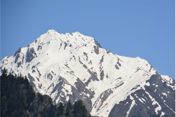
A very beautiful Sirbal peak was visible, which is 17175 feet high. I captured all the sceneries in my camera. We spent some time over there, had our lunch and moved ahead.
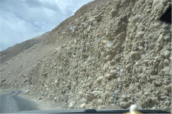
As you move forward, a very beautiful valley runs along the road side. Extremely beautiful. At most parts, the river running along was frozen. Roads were broken, many landslides were visible over the road and BRO (Border Roads Organisation) were still working to maintain motorable roads.

Snow capped mountains were quite visible and nearby. Fresh stream water was constantly running on roads as the snow was melting. As we moved ahead, Zoji -La (La itself means pass) pass arrived.

It is at the height of 11575 feet. It is a link between Kashmir and Ladakh valley. It is the second highest pass on the Srinagar – Leh highway. It is mostly closed during winter season. BRO is responsible for clearing and maintenance of the road during the winters.

When we entered this road, it passed through 20 feet walls of frozen snow on both sides. There was snow everywhere, in the valley, in the mountains, on the roads everywhere! Fully loaded Trucks were passing by these treacherous roads at the slow pace, and to me, these trucks were looking like proud mature village women passing through the village lanes with pots of water over their heads. It was wonderful all around.

At Zoji-La, the entire valley was covered with snow and many tourists go there to enjoy the snow. Many activities like skiing, sledding happen there. Because of many tourist vehicles parked along the road, there was a major traffic block and we were stuck there for almost four hours. We also got down from our car and started enjoying the scenic beauty. The temperature was around 5 degrees. But but it was comfortable and exciting. Then as the road cleared, we moved ahead. The roads were almost broken, there were walls of snow on both the sides of roads. It was extremely exhilarating.

As we moved ahead, Sindhu river which was completely frozen was running side by side. We could see lots of thrilled and happy faces of tourists all around us, fully enjoying the nature, just like us.

Full of joy and exploring a new world, we reached Drass. It is called the Gateway of Ladakh. We could see changes in the landscape from here. In Drass, there is a war memorial. The memorial is in the memory of the soldiers and officers of the Indian army, who were killed during the 1999 conflict between India and Pakistan.

There are a food and souvenir shop. As we went in, a commander told us the whole story of that war. We visited the Drass war museum and moved ahead.
As we moved ahead, I noticed that landscape was changing. It was getting drier, more rough and sandy.

We arrived at Kargil town, where we stayed for a night. And next day after breakfast we moved towards Leh. Around 45 km from Kargil, there is a famous Chamba statue in Mulbekh village.

It is a statue of Maitreya Buddha, built in around the 8th century. We visited it and moved ahead. Mountains started changing colors. Many khaki colored (light brown) mountains started showing. Now snow capped mountains were not much visible.

As this area is in a rain-shadow region, it gets very little rain or snow. Beautiful curvy roads were visible, as we moved ahead and when we looked back, we could see serpentine roads winding up the hills .
We then crossed Namik-La, which is a pass at the height of 12198 feet. No towns, no people around, just beautiful roads and beautiful weather.

When we found amazing views, we captured all those moments in our camera. Passing through this National Highway No. 1, we arrived at the highest pass of this region, Fotu-La Top at the height of 13479 feet.

Now the landscape was changing drastically. There were many colors on the hills. We noticed red, dark brown, purple colors on dry and sandy hills.
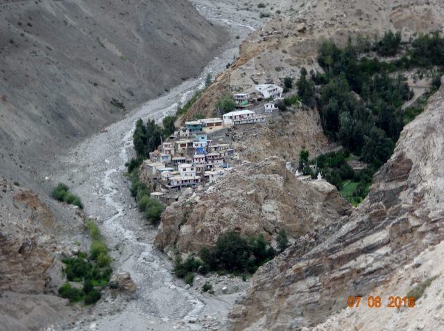
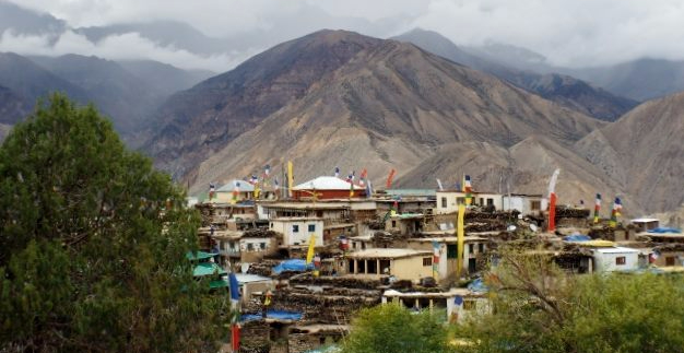
Then we reached near Lamayuru Monastery. As we took a turn, from distance we saw a village on the other peak and it was looking so beautifully picturesque. We all were more happy to see a village because we all were very hungry and it was the lunch time. We were sure that along with site seeing, we would also get a chance to have lovely local food.
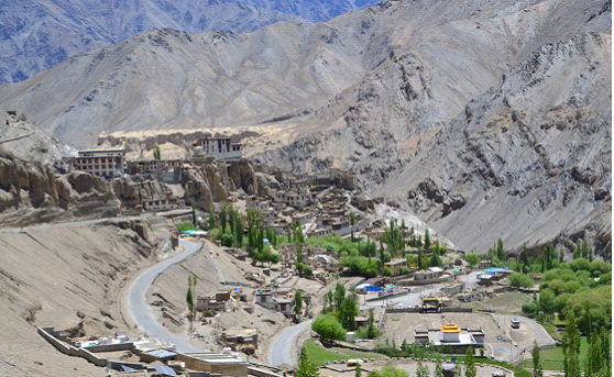
Lamayuru Monastery is located on the Leh highway at the height of 11520 feet. This is one of the oldest and largest Monasteries in the Leh region. There is famous Moon land behind this Monastery.
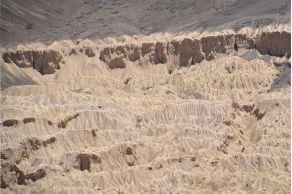
It is a muddy white mass of land which looks like the moon’s surface, created due to some unknown reasons. We saw some old broken structures and tunnel type old buildings behind this Monastery. We had a tasty lunch at a small restaurant and left.
As we traveled to Leh, there is an area called Magnetic Hill, near to Leh, which is a gravity hill. The layout of the area and surrounding slopes create an optical illusion that the downhill road actually looks like an uphill road. Now roads are more straight and well-built.

At the entry to Leh, we saw a big hoarding welcoming all – JULLEY, on the bank of river Indus. “JULLEY means Welcome.” Finally, we reached Leh, the capital of Ladakh region. Not a very big city but a small self-sufficient beautiful town.

Leh is at an altitude of 11562 feet. There was an important trade route between Tibet and Kashmir and between India and China through Leh for centuries. Leh Palace is one of the major attractions for tourists here.

The palace was built in 17th century by King Sengge Namgyal. It is a 9 story building. From Leh palace, we could see the whole Leh town in an aerial view. Other places of interest in Leh is the Namagyal Gompa, Cho khang Gompa, and Chamba Temple.

And in surrounding of Leh, there are few other tourist destinations like, Spituk Monastery, Stok Palace, Thikse Monastery, Shey monastery, Hemis Gompa, Basgo, Alchi Monastery etc.

Leh is surrounded by sandy landscape all around and there is a major camp of the army in Leh.
We stayed in Leh for three days. We visited almost all tourist destinations and enjoyed the beauty of the town. We walked through the lanes, had wonderful local meals, enjoyed local folk dances, and campfire nights at our hotel.
CONTINUE THIS BEAUTIFUL JOURNEY WITH SONA, IN PART 2 OF LADAKH DIARIES…… COVERING THE PASSES & LAKES OF LADAKH…

We stayed at Leh for three days. When u go to high altitude regions, you need to acclimatize, otherwise, you start feeling uncomfortable due to lower oxygen levels in the air. We had traveled to Leh by road, where we gradually climbed up the altitude, over a period of few days, so we didn’t face any problems. Yet we preferred to stay in Leh for three days, relax, get familiar with local culture and do the sight seeing.
For those traveling to Ladakh, it is mandatory to obtain inner line permits to visit certain areas. We took inner line permissions to visit restricted areas like Chushul, Tsaga, Marsimik La, and Chumur from the DC office. You need to take attested copies of valid nationality proofs like Passport, Voter ID, or PAN Card while going for permissions.
There are very few fuel stations in Ladakh. As we left from Leh, we made it sure that we carried a couple of extra diesel carboys of 20L for safety. It was a relief that the tank capacity of our car was 70 liters. There is very little or zero mobile network connectivity, once you leave Leh to travel into the interiors of Ladakh. .Only BSNL network or service is available in very few areas. After leaving Leh, we were virtually cut off from the outside world till we reached back to Manali.
The day we left Leh, there was a change in the weather. Storm of the previous evening was still there. The storm affected us in our next day’s journey. We fastened our belt for the further journey towards the beautiful lakes of LADAKH.

During traveling, we must try and maintain some discipline in ourselves. Eating only the right food, having sufficient food and liquid intakes at regular intervals, getting enough sleep, and leaving on time as per the schedule, to ensure that you stick to the planned itinerary, are some of the disciplines to be religiously followed.

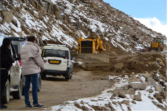
From Leh we left early morning for Nubra Valley, which is 159 km. from Leh. It takes around 4 to 5 hours to reach Nubra Valley from Leh. As we left Leh, We could notice fresh snowfall on the peaks of the hills, which must be due to the disturbance in the weather. To reach Nubra we had to cross KHARDUNG LA which is 39 km from Leh. Khardung La is a mountain pass at the height of 18380 feet above sea level, and one of the highest motorable roads in the world.

As we moved forward towards Khardung La. we noticed 3 to 4 feet of fresh snow on both sides of roads. Further on, at around 15 km from Leh roads were closed due to heavy snowfall and BRO was working on clearing the roads.
The weather was getting cooler. I was thrilled that we would be experiencing something new and exciting. Just before Khardung La, we got stuck in a long queue of vehicles for almost three hours. But all around us, there were white mountains and lovely views. It was all so magical and we all were enjoying the real Himalayan experience thoroughly. I took a small stool from my car and sat by the side of the road enjoying the nature.

As hours passed many tourists started getting panicky. Many of them chose to return back to Leh. Many of them also advised us to return back because they believed that it would be riskier to travel with kids, and self-driving on snowy roads is neither easy nor advisable. But we had decided to go further until the time we ourselves face any difficulties.We were confident and comfortable with the situation.

We had carried enough food and water for two days, just in case we face such road block situations. We had even carried a tent, so we were cool and kept moving ahead with confidence and having fun.
Khardung La was a great experience. As we moved ahead, the situation got tougher and tougher. BRO workers were working in those tough situations in freezing cold conditions. Snow got thicker and thicker on roads and by the sides of the roads. Many vehicles started struggling on snow covered roads. Drivers who couldn’t manage to drive were parking by the sides of the roads, or few others were pushing their cars through snow where the cars were skidding.

Due to snow covered roads vehicles were skidding, tyres were just rolling at many places. To drive in such terrain, it is advisable to drive 4×4 vehicle for safety. Indeed you need a brave and smart driver in such conditions. I still remember that one vehicle just ahead of us skidded 180 degrees. We kept safe distance and kept on moving ahead. All Trucks & military vehicles were driving with chains tied to their tyres.

Snow mode in our SUV, helped us to drive through the snow, without skidding. The whole experience was great and full of thrill.
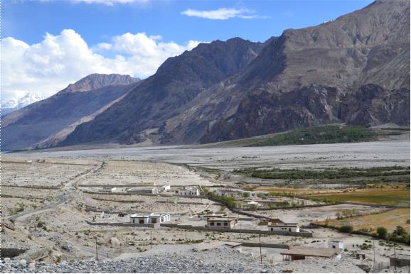
On the other side of the pass, we again entered a different terrain – which was dry and rough. We entered to the Cold desert region, the Nubra valley. LADAKH has got a range of diverse terrains, which we generally don’t get to see at any other place.
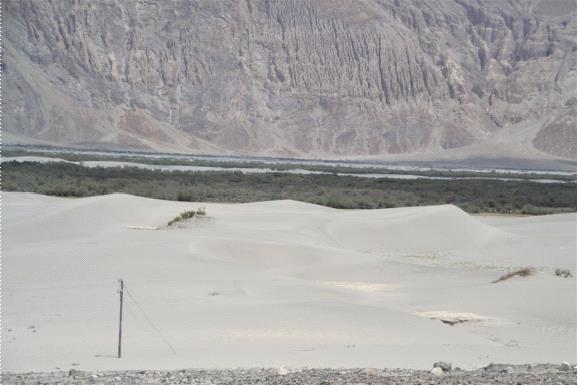
Nubra is a high altitude cold desert. Here Shyok river meets the Nubra river which is also called Siachen river. There is a huge river bed at Nubra Valley. We visited during early summer, so there was very little water in those rivers. HUNDER is a place in Nubra where cold desert is located. It is 12000 feet above sea level, which is one of the highest cold deserts. You find many Double Humped Bactrian Camels here.
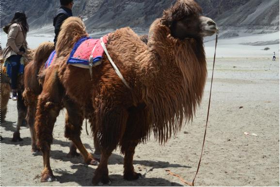
These camels are natives of central Asia. They were left behind here after the closure of the Silk Route.

There is a monastery in Diskit, which is the oldest and largest in Nubra Valley. As we were visiting this beautiful place, I was so thrilled to see the cold desert at this height.
From Diskit town, I bought some cucumbers and tomatoes to eat raw in the car during the further journey. In Diskit town, i saw a bus with the destination name plate of SIACHEN and I got so excited to see it because it is one the highest battle field in the world and pride post of the Indian Army.
From Hunder, we went to Panamik, at PANAMIK there is a sulphur hot spring. They have built a small building and facility to bathe in the hot spring water tub. In Ladakh, there is great scarcity of power supply and due to which there was always an issue of getting enough Hot water for bathing once we left Leh. We hadn’t taken a good bath at our tent because it was extreme cold. So we grabbed this opportunity for a Hot natural springs bath and got fully relaxed.
At NUBRA VALLEY due to the river, some parts are green and fertile. Many beautiful flowers and trees are seen here.

We stayed at NUBRA for two nights and we moved ahead towards Pangong lake. Here again the terrain was different. We know that THE GREAT HIMALAYA is a result of the irruption of the Ocean bed, and in fact here we could get to see the mountains made up of land similar to the bottom of the Ocean.
Hills are made of pebbles and layers of different colored soil or mud. To reach Pangong from Nubra, regular road is via Leh, but We took an internal route directly from Nubra to Pangong Lake, through the Shyok river bed, via Agam.

Hardly any tourist or even locals take this route as it is totally broken, and actually it drives through the Shyok river. We drove through the almost dry river. River bed was so huge, that it felt as if, an entire town could fit between its width.

On this back road, we crossed very few vehicles. No towns, no people around, and we couldn’t even find a bird for miles. This area was very dry and lonely but amazingly beautiful. As we passed ahead we saw some BRO workers working on hilly roads.

There a military vehicle crossed us, speed of both the vehicles was slow, and after few meters we realized that military vehicle had stopped and was looking at us. Both the vehicles reversed and we greeted each other. Military officer and his driver looked surprisingly happy to see us with our car number plate of MAHARASHTRA, as both the military men were from MAHARASHTRA. Then we parted ways and moved ahead.

We moved further ahead towards Changthang Valley. We crossed an army check-post, showed our permission to the officer and we moved ahead.There is a cold desert wild life sanctuary there, which is part of the HINDU KUSH HIMALAYA . The altitude is 14000 to 19000 ft. It has a natural grass lands and wide variety of more than 200 species of wild plants grow here.

As we arrived near Pangong Tso, we saw the first look of the lake, which was a breath taking view. It is such a beautiful lake surrounded by khakhi (light brown) coloured mountains.

The Pangong Tso is a situated at the height of 13910 feet , it covers an area of 134 Sq.kms in India and China. Approximately 60% of the length of the lake lies in China. The lake is 5 km wide at its broadest point. The water is salty but yet during the winters the water freezes.

Lake was so beautiful and mesmerizing, water was as clear as a glass. Closer to the shore, we could see the bottom of the lake. Wind created soft waves in the water of the lake. Place was very windy and freezing cold. The water of the lake looked same blue as that of the sky. Water kept changing colours with the time. Every hour the lake looked different.

There were brown headed ducks in the lake. These were migratory birds. The Pangong Tso (TSO means lake) is so beautiful one can not describe in the words. We stayed there for two days in the tents. We enjoyed this place thoroughly .

From Pangong Tso, we moved towards Tso Moriri. Again we took an internal road to Tso Moriri, which is passing by the Indo china border almost parallelly. There were no roads, very less towns, no people around, totally lonely area.

All you could see at a distance, were military bunkers on the hills along side. It was a sensitive area, very close to the border.
As we were crossing a small village of few homes, a gentleman on the road there, asked us as by which route we are going to Tso Moriri. He explained us how to reach there and told us about road conditions. He also advised us that after few kilometers, we would reach to a jungle and left hand side we would see a bridge but we strictly shouldn’t go that way, as there is Chinese check-post across that bridge.

As we left Pangong Tso via the rugged backroad, there were no roads actually. We had to just locate tyre marks on the terrain, and keep moving forward. Road was along the Pangong lake. For many kilometers, Pangong Tso accompanied us and at one point we said goodbye to the lake, lake moved further ahead into the China side and we kept moving on our way to Tso Moriri.

All around, there was only tableland and surrounded by mountains. At many places, it so happened that due to the wind there were no tyre marks, we had to stop for a while and then decide which route to take and move forward. There were no sign boards, no GPS or directions, it was surreal.


On the way we passed, Changthang Wildlife Sanctuary, where we saw many Kiangs, wild yak, Great Tibetan Sheeps, beavers, etc. Kiangs found in the open sandy tablelands live in herds and eat sturdy grasses. Black necked crane, Brahminy ducks, Bird-headed Geese, many other migratory birds breed here.

On that road, there is war memorial at REZANG LA , in Chushul Valley. This valley is 3000 yards long and 2000 yards wide at the height of 16000 feet. The small memorial at Rezang La, is a site for paying respect to the martyrs of SINO-INDIAN war 1962.
En route to TSO MORIRI we saw another lake KYAGAR TSO. Again here, water of the lake is salty. We stopped over by the lake, but it was so windy that even our car was shaking. We were thinking to go near the lake but from far distance we noticed marshy land and could not go there.

One vehicle with a localite passed through. He stopped by and started chitchatting with us. He advised us not to go near the lake. According to him, the water of the lake was full of sulphur, so if you touch it, there was a chance that you may get severely burnt. So we stayed there for a while and moved ahead to Tso Moriri.

We could see KYAGAR TSO from distance en route to TSO MORIRI. There were flat tablelands everywhere around us. At Kyagar Tso, We saw a concentric circles of many colors. There was a big round patch on the ground surrounded by parrot green and in the center it was nice bright pink. We kept moving, with full of joy and enthusiasm. A frozen rivulet was passing along side the road. Many nomads were there with their herds.

After 30 km or so we got to see Tso Moriri. This drive was very tough and draining. We came all the way through lonely dangerous roads. Finally we reached Tso Moriri by noon. Before entering the town, there is a check post. We showed our permission letter and moved towards the lake. Weather was much chillier here than earlier places.

It was too windy, very difficult to stand in the open in such conditions. But it is a very nice blue colored teared shaped lake. This lake is at the height of 14836 feet. It is the largest of the high altitude lakes entirely within India. It is about 26 km north to south in length and 3 to 5 km wide.

Here weather conditions were very rough and harsh. During the day time, we enjoyed around the lake and by the evening we went back to our camp. By the evening weather started changing. It was getting stormy, so we preferred to stay in our camp only. In the camp, there was a dining area and they had gas heater. We kept ourselves warm, had our dinner and went to the tents.


We had booked two tents but after seeing the storm and extremely harsh weather, we preferred to stay in one tent only. It was very windy and scary too. The temperature started falling rapidly to sub-zero levels. I kept wondering that how these local villagers were surviving, especially without any electricity or heating. One small stream was passing by my tent. Next day morning that stream turned into a frozen stream. We had a plan to stay there for two days but weather condition was so terrible, that we decided to move ahead to Manali.
Next day morning, we asked a hotel boy to pack some food for us for the journey. We had our breakfast and moved towards Manali.
As we moved ahead, we passed a region which was looking like some other planet. There was very marshy land, river bed type grasslands and hot water springs.

Hot water from the springs was coming out with so much force from the ground, that it was scary. This area is called PUGA GEOTHERMAL FIELDS. It is a 12 km long valley with the width of 1 km.

There was very marshy land along the road. One spring was by the side of the road, I wanted to take a picture of it. Temperature would be around 2 to 4 degree celsius. As I opened the car door, a strong smell of sulphur ran through my nose. I felt scared.

That area was so lonely, there was no human settlement for miles & miles. I took many pictures of the springs from distance. Land around this valley was surprisingly colorful. We got to see many colors like pink, light green, all absolutely amazing. It was due to heavy portion of minerals in the soil.
As we crossed Puga Valley, we again came to tableland. From a distance we saw another lake. It was TSO KAR.
This lake is famous for its size and depth. It is fluctuating salt lake situated in the Rupshu valley. Few years ago the lake was important source of salt. Changpa nomads used to export salt from here to Tibet. Climate is extreme here, in winter goes down to -40 C and in summer rise up to 30C.

Around the lake, we saw around 3 to 4 feet high piles of salt. Again there was very marshy land , around the lake and we could not go near the lake. We stopped there for while to enjoy the extremes of nature, but we remained in the car only because there were lots of mosquito around due to the marshy land. We clicked some pictures and moved ahead.
We passed through very rough route till we approached the Leh-Manali highway. In few hours by late noon we reached Pang in Himachal pradesh. At Pang we had nice Tibetan home food and moved ahead.

Now we entered the Himachal Pradesh, the land of the GOD. It was truly heavenly feeling after seeing so much dry and harsh area. As we entered Himachal Pradesh everything was again different. Lots of green mountains around and many more people than the Ladakh region.

We passed through LACHUNG LA , which is at the height of 16616 feet and 24 kms from Pang. As we moved ahead towards Manali, we were again climbing steep mountains and passes were getting higher. Then we reached Baralacha La. This is my most favourite pass.

That time of the year, it was fully covered with snow, with few brown rocks jetting out. All the mountains around were looking like heaps of vanilla ice-cream with choco chips sprinkled over it.

It was a beautiful pass indeed. We were coming all the way from TSO MORIRI, and all were very tired. Even the roads were not so good, with hardly any places to come out of the car and relax a bit, due to heavy snow all around. Car was also moving at a very low pace. Temperature was around -2 to -5 degrees in the afternoon, we were all quite exhausted by that time, only the serene beauty all around kept us in some good spirits. We passed through a beautiful frozen lake, which was Vishal Taal.

After crossing Baralacha La ,we came to a place called Zingzingbar, which had a road building camp and there was a tea house. After the tiring journey, we got down from the car, had some tea and snack and further moved ahead to Jispa town for the last overnight stay before Manali.
We reached Jispa by evening 5pm. We stayed there for a night and next morning after breakfast, we left for Manali. After seeing the beauty of Baralacha-La, Rohtang pass was nothing. One must travel through Baralacha La pass during snowy season.
Finally we reached to Manali by 4pm. We stayed in Manali for three days.

In Manali, we just relaxed, and again re-charged our spirits for the grind of the city life, that was awaiting us. We bid adieu to the Himalayas and left for Chandigarh. We reached Chandigarh by night the same day. Stayed there for a night and next day after lunch we took a flight to Mumbai, and reached back home by late evening.
From Chandigarh our driver took a car from us and drove to Mumbai in three days.
This was our most memorable road journey, where we traveled from Mumbai to Ladakh and back, 6500 kilometers in 21 days. Hurray!!!!!!
In early years, say till the 80’s, there were many joint families, now the number of joint families are reducing and in metro cities, there are almost none. Nothing much has changed as such, except technological advances and modernization of the world around. Today I feel alone, in spite of having long distance family members and relatives. Today’s modern age time has given us loneliness. We like to spend more time with gadgets. We are actually not enjoying from within, but most of the time we use gadgets to kill our boring time, and loneliness.
Today, the situation is such that I sometimes feel confused about which time of my life was good? Today or earlier. In metro cities, life is hard and harsh in a way. You can get each and every technology, fashion, entertainment, everything for outer happiness, for which you have to barter, give money and buy happiness. How sad is it? Today we are unable to get pure happiness which gives us actual pleasure and calmness of mind. Today when I go to my hometown I feel so good. I feel like I am back to my roots. Suddenly my body and mind get calm, comfortable and at peace.
I feel so calm and secure when I am around my older relatives. I feel safe and secure with them. Earlier, people were not so arrogant, mean, and rude. I feel today’s generation is in stress due to many reasons. People have to take help of online jokes to smile. Inner happiness is dying. I am happy today, but when I say I am happy, I don’t get the same feeling of happiness from within.
Today, I don’t find any soulful relations. Relations and relatives are there – just that they are there. Nothing much. There is no bond. That way, I prefer the joint family system. In the house there would be so many people, whom you can call yours, to take care of each other. To spend quality time together. Mom, aunts, sisters, cousins, brothers, all are there around, just for you. You don’t have to call them or take their permission and ask if they are free to meet. Today, we try to find our close ones like sisters, brothers, uncles and aunts in those people who are not our even distant relatives. The family system is breaking and it is affecting our lives.
Earlier three to four or more families could stay in one house with harmony, today even a family of four, is not ready to share the house. Tolerance level has gone to zero. Love and respect have been reduced to mere words.
According to me, we are missing our large family system. People around us are not our family. Constantly, we have to adjust all around and that gives us stress. That’s why we don’t feel safe and secure in this modern age and in metro cities.
I have kept a picture of my extended family members in my house which gives me a safe and secure feeling, just by looking at it. I feel that my family members are around me to take care of me.

City of seven Islands. City of dreams, Mumbai. Mumbai has its own rich cultural heritage. Mumbai is beautiful because of old British era monuments. It is always a dream destination for many Indians. Bollywood, Fashion, celebrities, top level businessmen, nightlife, parties, spectrum of cuisines, seaside restaurants, various kinds of pubs ,Juhu beach, Prithvi theater, Bandra band stand, princess necklace marine drive, Gateway of India, Taj hotel just opposite the Gateway of India, old Monuments, buildings such as The Asiatic Library and many more were great attractions for me.
I always wanted to settle here. In my very early age, I had seen old Hindi movies which were shot in Mumbai city, they attracted me greatly towards Mumbai. It was a dream destination for me as a child.
I was very excited by the thought of staying in there. I adapted to Mumbai city. I did not feel alienated in Mumbai anymore.
Passing the time of life, family growing, responsibilities has grown bigger but nature of exploring new things around me remained the same. What I love the most about Mumbai is its vibe. Here, the vibes are very young and energetic. People are always ready to party up late. It is safe to move around any time of the day. Of Course, earlier it was safer, sometimes we feel that we are not so safe, knowing about the incidents in other cities and so..but I still feel safe. I have driven myself home at midnight from parties, ‘Touchwood’, I have never faced any problems.
I love to stay in Juhu. I get plenty of good vibes when I pass through lanes of Juhu. It gives me the best vibes of my life. Mumbai has so much warmth. Partying with friends here is safe too. They are trustworthy. You can move around with them anytime, safely. Here, females of all ages are safe and can experience fun. I used to go to pubs, late night parties regularly, I have never experienced inconvenience caused by drunk guys. I must appreciate that even if you are at the crowded place like pubs, shops or markets nobody will touch you inappropriately. That is the culture of this city.
Mumbai city resides at bay. Mumbai has its own smell. Mumbai is airy, humid, sometimes hot and evenings are pleasant. I love the smell of Mumbai. Nowadays other smells ruin it but the original smell of Mumbai is what I am referring to. I love to visit restaurants which are located on the beach side. Sitting on a ledge of the seaside hotel restaurant, you can see people roaming around the beach, kids playing in the sand, young boys playing football and cricket, soft waves coming and going, constant air coming by sea touching your hair and face, feels great.
Mumbai is a great city. Here in Mumbai, there is no competition amongst the people. No show offs for sure. No being put down by others, everyone respects each other. Mumbai is a peaceful city. Mumbai is a city of stars, the city of tycoons, many of the richest tycoons live here. People with different financial statuses and diverse cultural backgrounds, diverse professionals stay here but all respect each other. Celebrities are spotted around us plenty of times but they never make us feel awkward, they are always comfortable even in common places like restaurants. Here in Mumbai, nobody is bothered by others. Everybody lives in harmony and peace.
Mumbai is a very calm and mature place with culturally matured people. In difficulties like natural disasters, everyone supports each other. You never feel left out in this city. Interesting is when you visit the best hotels, restaurants and famous places; nobody brags or shows off. Everyone keeps their noses out of others’ businesses. Nobody is interested in what you wear, no price tag competitions here, unlike other metros. I feel so comfortable in Mumbai. This is one of the reasons why I like Mumbai the most.
Mumbai is at its best when it is the monsoon. It gets so beautiful in monsoon, Mumbaikars go crazy in the first rain of the season. Monsoon in Mumbai is like a great festive season for all. During rains, I love to go and sit on the Marine drive ledge, love to visit Bandstand. It looks so beautiful, looks like the city is dry cleaning itself.
We often visit Lonavala during rains. It is one of the best experiences. Last time during rains, I visited Nasik and the Bhandardhara lake. It is also worth going to during rains. It keeps raining constantly at the same pace for many days.
Mumbai is for all. Nightlife is beautiful. You can experience all kinds of fun, you can get food by midnight at many places. Chat items, Egg Bhurji, south Indian dishes, Pav bhaji many more items to enchant your taste buds at midnight.
Mumbai is a city of celebrations. All different communities celebrate their festivals with peace and harmony. Mumbai celebrates its festival for a long duration. Mumbai starts celebrating festivals from August to March. I start my Ganpati celebrations with LED lights which remain on windows for decorations till new year.
Mumbai has its own nature. Here people love to stay happy and calm. No agitating each other. Traffic has increased drastically in the last 10 years but is still manageable and disciplined.
Mumbai has a big heart, it adopts everyone seeking a place to belong to. I feel Mumbai loves me and I love Mumbai.

After a two day stays, we moved ahead to Kalpa. Kalpa is around 61 km. from Chitkul. Just before Kalpa, there is a town called Reckong Peo, which is the headquarter of Kinnaur district. We had our lunch there and moved ahead to Kalpa which was around 3 km from there.
Kalpa is a small town in Kinnaur region. It is located at the base of the snow-capped Kinnaur Kailash range. The Shivling like peak rises up to 20,000 feet. We stayed there for a night and next day left for Nako. Nako is around 100 km. from Kalpa.

As we moved ahead, the terrain got rougher, the landscape changed. The dry grayish region started appearing. Near Khab there is a confluence of Spiti River and Sutlej river. Here, Sutlej enters into India from China. Both the rivers had gray muddy water. China border is very near to this place.
Now Spiti river was running by the roadside. Hills were dry and there were some green patches around Spiti river. We stopped at a small place and inquired if some food was available.

The lady of the house welcomed us with a lovely sweet smile. Her name was Meena Kumari. She was selling groceries in her small house. She had a small farm behind her house. There were apple trees, walnut trees, tomato plants and plants of green peas. We had local food at her place. I captured some of those moments with her in my camera.
Now Spiti river was running by the roadside. Hills were dry and there were some green patches around Spiti river.
Before Nako, there is a place called Leo village, on the opposite mountain. We went to see the beauty of that town by an interior road. We could see the banks of the river Spiti. Surrounding area was dry, only a few parts of the hill were green and lots of Apple orchards were there. It was beautiful. We spent some time over there and moved ahead to Nako.

Nako is the largest village in the Hangrang Valley at the height of 11,893 feet, with the back drop of Reo Purgyal, which is at the height of 22,362 feet, the highest mountain in Himachal Pradesh. The village is located near Indo-China border. There is a small lake which is created on the slopes of the Reo Purgyal mountain of Srikhand range. There is a Nako Monastery there, dated to the 11th century.


We stayed there for one night and next day morning we had left for Tabo, which is around 64 km from Nako. Roads again were very much rugged.

We could see only blackish mountains and muddy Spiti river. There were hardly any vehicles on roads. Here the terrain was very different.


At Sumdo, we showed our permission letters to the duty officer. We had asked for permissions for visits to Kaurik and Shipki La, which are near Indo-China border. But due to sensitive reasons, they didn’t allow us to visit those places. So we reached Tabo directly.
Tabo monastery founded in 996 AD, by the Tibetan Buddhist Rinchen Zangpo, the king of western Himalayan Kingdom of Guge. A large number of frescoes are displayed on its walls. There is a collection of scroll paintings, manuscripts, well-preserved statues in the Monastery. Frescoes and murals cover almost every wall.
")


A Tibetan lady who was taking care of monastery looked very old. There were many deep wrinkles on her face. She must have seen many decades in her life. I requested her if I could take a picture with her, but she refused. I asked her age, she counted in her mind and she tried to remember any big historical incident that happened during her birth. Then she told us that she was born around 1916. I don’t know if that was the exact year but I am sure that she was more than 98 years old.

There were many souvenir shops around the monastery, I bought a special ancient pot, a wooden prayer wheel and Tibetan Tingsha (manjira or prayer bells). We then left for further journey.
From Tabo, we left for Dhankar Monastery, which is about 31 km. from Tabo. Dhankar town was the capital of Spiti Valley earlier. Dhang means cliff and Kar mean fort. Hence, Dhankar means a fort on the cliff. It is at the height of 12,774 feet.


We had to ride 23km on internal roads from the main road. Many tourists also trek on this route. As we moved ahead, we saw a small town at a far distance on another hill. It was a very picturesque site. We reached Dhankar and rode through the town, and around the Dhankar Monastery.

Their many home stay options were available. Then we rode down from another end of the hill, which again met the main road back towards Kaza. There is a confluence of river Pin and river Spiti, in the Pin Valley, en-route.

We rode on to Kaza, which was around 34km from Dhankar. River Spiti constantly accompanied us. Kaza is a high altitude cold desert having close similarities to the neighboring Tibet and Ladakh.
We reached Kaza by late afternoon. We relaxed for a day, visited Kaza town and came back to the hotel by dark. Next day we had plans to visit surrounding of Kaza town.
We packed some sandwiches and soft drinks with us. We left to go around 60 km area of upper regions of Kaza. Roads were rough, but the scenery was amazingly beautiful. There were few towns over there and they do farming there.
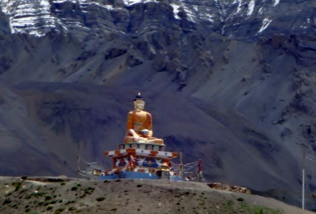
From the far distance, we could see huge Budha statue, which is at Langza village, with the back drop of Chau Chau Kang mountain.


All the houses are built below this statue. Langza is situated at the height of 14,500 feet. Langza is also considered to be one of the highest village in the world with a motorable road. It is a very small town with around 30 to 40 houses. Crops such as Rice and Potatoes are cultivated here. There are no options of hotel stay here but only home stays, that too with basic facilities are available.
The main attraction at Langza was to collect fossils. Fossils of marine creatures and plants are found in plenty here under sedimentary rocks. These fossils are millions of years old.
When we reached Langza, many small children were playing there. They gathered around us and took us to their houses to sell fossils. People of the town were very welcoming. All the children got their collection of fossils and started showing us. Children were very much conscious that we should not take pictures of their collection of fossils. I bought few fossils from there. We chatted with local people and moved ahead.


We then reached Hikkim. This location is credited to have World’s highest post office in India. The houses in the village are clustered just below the road. It is a steep walk down to the village houses and the Post Office also.

")

It seemed that the place was also available for homestay. We spoke to the postmaster, gathered some more information about the post office and the town. And then we moved ahead.
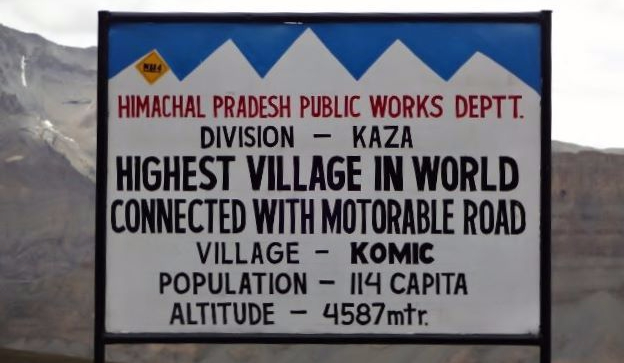
From there, our next stop was Komik village. It is situated at the height of the 15,027 feet. Komik is supposed to be the highest village with a motorable road in Asia. This village is also believed to be the highest village in the World.

By that time weather changed. Rain started to drizzle. It was very windy. We spent some time over there and came back to Kaza by the evening.
We had a good party in candle light in the night, as there was no power! But we had a great time.
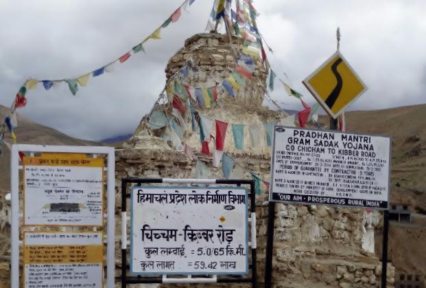
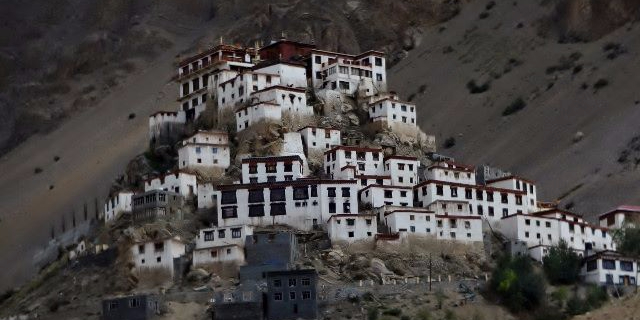
Next day morning, we visited Kibber village and the Key monastery. Key Monastery is the biggest monastery in Spiti Valley.
Then we rode further towards Chandra Taal. It is around 89 km from Kaza. The terrain was dry but beautiful. As the day progresses, there are more chances of streams flowing in full force.

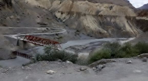


We crossed many streams on the roads, it was really very beautiful.

We reached Kunzum pass. It is at the height of 15,060 feet, a high mountain pass. There are Kunzum stupas and Kunzum Mata temple. We spent some time over there and moved ahead.
")
")
We reached at Chandra Taal by afternoon. Chandra Taal means Lake of the Moon. The name of the lake originates from its crescent shape. It is at the height of 14,100 feet. From the camp site, vehicles can go only certain distance up to the lake and thereafter, there is around 1.5 km walk till Chandra Taal.

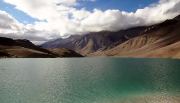

The lake was very scenic. There were dry mountains all around Chandra Taal. We stayed in a tent at Chandra Taal for the night and left next day morning for Manali.
")
")


Roads were really bad and rocky. Many water streams were crossing the roads on this route. It was difficult to ride pillion on the bike, so I had to cross streams by walking.
Stream water was very very cold, I had to remove my shoes and socks so that they don’t get soaked with water and I didn’t want to catch a cold towards the end of my wonderful journey.

We had a Jeep as a backup vehicle with us. The driver advised me to sit in the Jeep while crossing the water streams. So I did the same. At one place the water was in great force, pebbles were slipping as vehicles were passing over them.

My riding partner tried to cross the stream but the water was above ankle level, gushing with a great force. He had to try hard and only with the help of the vehicle driver, he could move out of that stream. It was a thrilling experience.

Again there was a big stream ahead, a biker coming from the opposite direction also struggled. My riding partner helped him to come out of the stream. On such routes, it is always advisable to have a backup vehicle while going on a ride.
Passing through constant water streams, rear brakes of the bike failed. There was no other option, but to ride till Manali with care. From Gramphu, we took the Leh-Manali highway to Manali. The rain had started, it was tough riding in rain and cold.

As we reached Rohtang pass, there was almost zero visibility, but somehow we managed to reach Manali safely, with only front brakes. That was a very long and tough day.
As soon as we reached Manali, we went to get the breaks repaired at the authorized RE workshop, where it took almost two hours to get the repairs done. By late evening we reached our hotel. After leaving Chandigarh, this was the first comfortable stay we had.
Next day morning, we left for Chandigarh. It is 309 km from Manali. Manali-Chandigarh highway is a very busy highway. It was very tiresome. Constant traffic on the road. It took us 8 hours to reach Chandigarh. We stayed there one night and next day afternoon we took a flight to Mumbai, after giving our bike to the transporter.
Our bike came by transport within a week.
It was a truly memorable riding trip of Spiti Valley.


